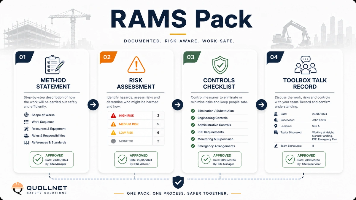
Method Statement: Establishment of Primary Survey Control Network – Method Statement
AI-assisted method statement with matching ITP, PDF download, and Excel export.
More than a static template
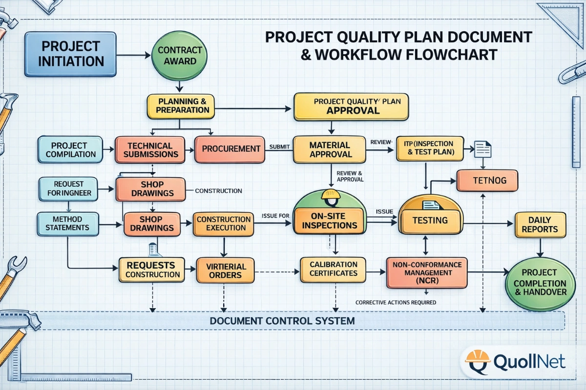
Unlike a downloadable Word or PDF template, this method statement is an AI-assisted editable starting point connected directly to a matching Inspection and Test Plan. Every section is structured, project-adaptable, and ready to export.
- AI-assisted drafting — Customize every section with AI for your specific project scope.
- Linked ITP — A matching inspection and test plan is generated alongside the method statement.
- Multiple export formats — Download as a formatted PDF or editable Excel spreadsheet.
- Editable starting point, not a final document — Review, verify, and adjust all content against your project requirements before use.
Static template vs. Quollnet workflow
| Feature | Static template | Quollnet |
|---|---|---|
| Project-specific content | Manual fill-in required | AI-assisted customization |
| Linked ITP | Separate document, no link | Matching ITP included |
| Export formats | Usually PDF only | PDF and Excel |
| Structured sections | Free-form layout | 13 standardized sections |
| Saved to your account | Local file only | Cloud-saved, reusable |
| Content accuracy | You verify everything | AI-assisted, you still verify |
| Cost | Often free but time-intensive | Free to customize and download |
What you can customize
When you save this method statement to your account, every section becomes editable. The following 13 sections are included:
- Scope — Defines the activity and its boundaries.
- References — Standards, specifications, and drawings.
- Responsibilities — Roles and accountabilities.
- Resources — Labour, plant, and equipment summary.
- Materials — Materials and compliance requirements.
- Equipment — Tools and equipment details.
- Prerequisites — Hold points and pre-conditions.
- Method sequence — Step-by-step construction sequence.
- Safety controls — HSE risk controls and PPE.
- Environmental controls — Environmental mitigation measures.
- QA/QC — Quality inspection and test requirements.
- ITP — Inspection and Test Plan table (has its own page).
- Attachments — Referenced drawings and documentation.
Why this method statement is used
This method statement is used to define and communicate the approved procedure for carrying out method statement: establishment of primary survey control network on site. It ensures the work is planned in advance, the correct resources and controls are in place, and all personnel understand responsibilities, sequence, quality requirements, and safety controls before work begins. It aligns site execution with the documented scope and acceptance expectations.
Who uses this method statement
This method statement is used by contractors, site supervisors, project engineers, QA/QC engineers, HSE officers, consultants, and client representatives. It serves as a shared reference for planning, execution, supervision, inspection, and approval of the activity on site.
When it is prepared and submitted
The method statement is prepared before the work activity starts and submitted as part of the pre-construction documentation package for review and approval.
Who reviews or approves it
The method statement is usually submitted to the client representative, consultant, resident engineer, or project management consultant for review and approval before the work commences.
Important approval note
This method statement is an AI-assisted editable starting point, not a pre-approved document. Before use on any project, all content must be reviewed and approved by the relevant parties (superintendent, principal contractor, or client representative) in accordance with your contract and project quality plan.
For example: if your specification requires a departure from a referenced standard, that departure must be documented and approved separately — this method statement will not capture that automatically. Always verify against your applicable drawings, specifications, and regulatory requirements.
Method statement content
Scope
Purpose
Define the procedures to establish, verify, protect, and document the Primary Survey Control Network to which all subsequent setting-out activities will be referenced.
Scope of Work
- Review and approval of Survey Control Plan and network design.
- Reconnaissance, utility clearance, and selection of control point locations.
- Monumentation of horizontal and vertical control (surface and protected monuments).
- Instrument calibration and verification (GNSS, total station, levels, staffs, prisms, tribrachs).
- Coordinate transfer from project/national datum (horizontal) and benchmark verification/transfer (vertical).
- Observations (GNSS static/rapid-static; total station traverse; precise differential leveling).
- Network adjustment (least squares), residual analysis, and acceptance against tolerances.
- Independent QA/QC checks and closure loops.
- Protection, marking, and surveillance of control points.
- Documentation: control register, adjustment reports, calibration certificates, field books, raw files, as-built coordinates/drawings, photographs.
- Hold/Witness points for Consultant/Engineer review and approval.
Deliverables
- Approved Survey Control Plan.
- Primary control coordinate register (final, adjusted; grid and datum stated) with uncertainty metrics.
- Benchmark verification report and leveling loops.
- Network adjustment report (pre/post adjustment statistics; residuals; error ellipses).
- Calibration/verification certificates and daily check logs.
- As-built drawings and point protection details.
- Handover package to enable setting-out.
Exclusions
- Secondary control densification and detailed setting-out are excluded; they shall reference this primary network.
Constraints/Assumptions
- Final datum definitions, geoid model, and project grid to be confirmed by the Employer/Engineer. [Verify per project specifications]
References
| Document Type | Reference / Number | Revision | Notes |
|---|---|---|---|
| ISO 17123 series – Field procedures for testing geodetic and surveying instruments (Parts 3 Levels, 5 Theodolites/TS, 8 GNSS) | Instrument verification and field test guidance | ||
| BS 5606 – Accuracy in building: guidance on tolerances and setting out | Accuracy and tolerance guidance for construction works | ||
| BS EN ISO 4463-1 – Measurement and setting out of buildings | Procedures for setting-out and dimensional control | ||
| ASTM E3125 – Standard Guide for Global Navigation Satellite System (GNSS) Measurements | Field GNSS practice, accuracy, and metadata | ||
| ASPRS Positional Accuracy Standards for Digital Geospatial Data (latest) | Positional accuracy reporting; error ellipse concepts | ||
| ISO 9001 – Quality management systems | Document control and quality records for survey activities | ||
| Project Specifications and Drawings | Project grid/datum, tolerances, hold points, approvals [Verify per project specifications] |
Responsibilities
| Role | Responsibility | Name / Party |
|---|---|---|
| PM | Project Manager | Contractor |
| Chief Surveyor | Chief Surveyor | Contractor |
| Survey Lead | Survey Party Chief | Contractor |
| Surveyor | Surveyors/Instrument Operators | Contractor |
| Assistant | Rodperson/Assistant | Contractor |
| QA/QC | QA/QC Manager | Contractor |
| HSE | HSE Manager | Contractor |
| Coordinator | Utility Coordinator | Contractor |
| CAD/BIM | CAD/BIM Lead | Contractor |
| Engineer | Consultant/Engineer | Engineer |
| Doc Control | Document Controller | Contractor |
Resources
| Resource Type | Description | Quantity | Remarks |
|---|---|---|---|
| Personnel | 1 | >10 years major project experience [Verify] | |
| Personnel | 2–3 crews | As per program | |
| Personnel | As required | If working adjacent to live traffic |
Materials
| Material | Specification / Grade | Quantity | Remarks |
|---|---|---|---|
| SS pin M12–M16 | 316 SS; length 150–250 mm [Verify] | As required | |
| Ready-mix concrete | C25/30 or higher; 20 MPa @7d [Verify] | As required | |
| Grout/Epoxy | ASTM C1107 (grout) / anchoring epoxy per manufacturer | As required | |
| Galvanized steel/HDPE | High-visibility, reflective bands | As required | |
| Survey paint/tags | UV and weather resistant | As required |
Equipment
| Equipment | Capacity / Type | Quantity | Inspection Required |
|---|---|---|---|
| GNSS receivers | L1/L2/L5; tracked constellations GPS/GLONASS/Galileo/BeiDou | ≥2–4 units | Calibration/firmware verification; antenna height measurements to mm precision |
| Total Station | Prism/non-prism modes | ≥1 | Collimation/EDM constant check per ISO 17123-5 |
| Digital level | Std dev ≤0.7 mm/√km double-run [Verify] | ≥1 set | Two-peg test per ISO 17123-2/3 |
| Accessories | Sets as req. | Bubble/tribrach runout check | |
| Core drill | Diamond core 50–100 mm | 1 | PAT/electrical checks [Verify per HSE plan] |
| Utility locator | As required | Operator certification; calibration sticker | |
| Traffic control | Sets as req. | Per approved Traffic Management Plan |
Prerequisites
- Approved Survey Control Plan (network geometry, number of points, methods, tolerances, observation schedule).
- Confirmation of project horizontal and vertical datums, site grid, projection parameters, and geoid model. If not issued, propose and obtain approval. [Verify per project specifications]
- Drawings and existing control/benchmarks received from Engineer including any grid-to-grid transformations.
- Utility clearances and Permit-to-Dig for each monument location; GPR/cable location where intrusive works occur.
- Traffic Management Plan approved where work is near live roads.
- Instrument calibration certificates within validity; daily/weekly field check procedures in place per ISO 17123.
- Competency records of surveyors and equipment operators.
- HSE risk assessment and method statement briefing (TBT) completed; permits for night works or roof access if applicable.
Method Sequence
| Step | Activity | Description | Responsibility | Inspection / Hold Point |
|---|---|---|---|---|
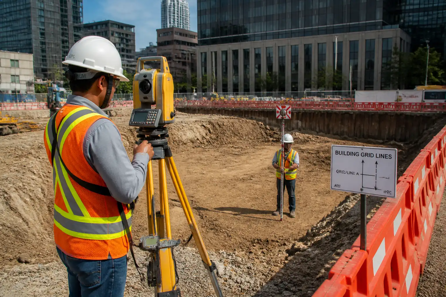
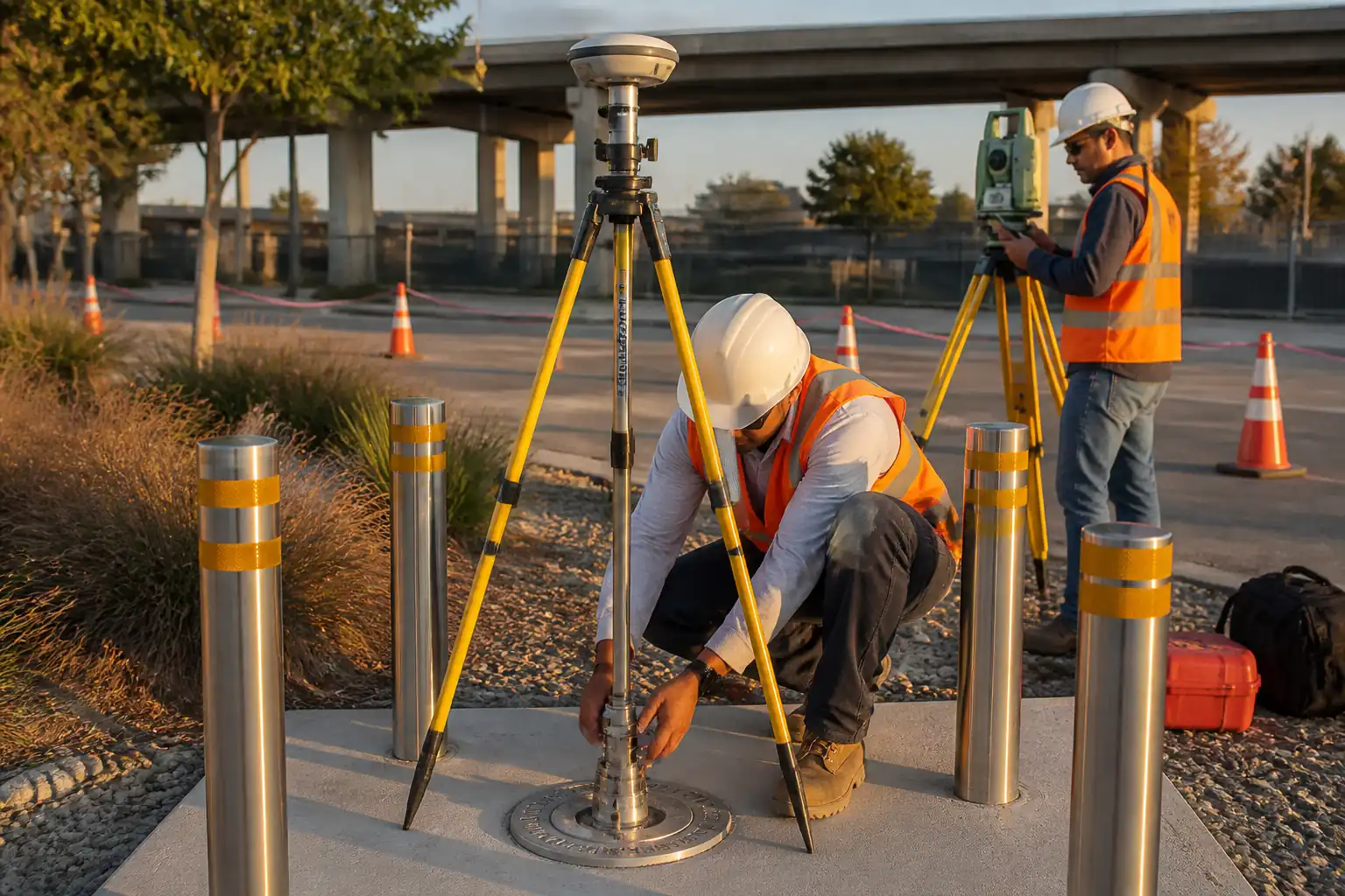
| 1 | Reconnaissance and Network Design | Site walkover to assess satellite visibility (>15° mask), intervisibility, security, ground conditions, utilities, and access. Propose ≥4 primary control points forming a braced quadrilateral or polygon encircling the works, with at least two points outside construction influence. Prepare layout drawing with proposed monument types. | Chief Surveyor | Hold Point: Submit Survey Control Plan to Engineer for approval before works |
| 2 | Utility Clearance and Permits | Obtain utility maps; mark suspected corridors; conduct GPR/cable location where intrusive monumentation is planned. Secure Permit-to-Dig and traffic permits as applicable. | Utility Coordinator | Witness |
| 3 | Instrument Calibration and Daily Checks | Verify TS collimation/EDM constant, prism constant, and tribrach runout; perform two-peg test for levels; GNSS receiver/antenna firmware and antenna heights measured to nearest mm. Record daily checks on control peg/known baseline. | Survey Party Chief | Surveillance |
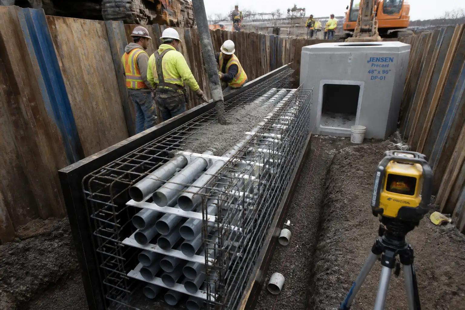
| 4 | Monument Installation | Set stainless pins or cast-in monuments on stable ground/slabs. For ground points: concrete plinth ≥300x300x300 mm with SS pin grouted/epoxied; for pavement: core hole Ø50–100 mm, epoxy SS pin flush or recessed; for protected points: install bollards/guards and marker posts. Stamp unique ID. | Survey Party Chief | Witness |
| 5 | GNSS Static/Rapid-Static Observations | Occupy all primary points in ≥2 independent sessions at different times of day. Session duration: Rapid-static 20–45 min for short baselines (<5 km); Static 60–120 min for longer baselines (>5–15 km). Use choke-ring or geodetic antennas where multipath risk exists. Log to RINEX. Record antenna type/serial and ARP-to-mark heights to nearest mm. | Surveyors | Surveillance |
| 6 | Traverse Observations (if required) | Establish closed traverse between primary points or to densify. Observe angles in at least two sets, faces left/right; distances measured with temperature/pressure inputs. Use forced centering. Include resection checks. | Surveyors | Surveillance |
| 7 | Differential Leveling (Benchmarks) | Establish/verify vertical control by double-run differential leveling closing on at least two independent benchmarks. Keep sight lengths balanced (diff ≤10 m). Avoid heat shimmer and traffic vibration. | Surveyors | Witness |
| 8 | Processing and Least Squares Adjustment | Process GNSS with appropriate ephemerides (rapid/final), apply antenna calibrations, resolve ambiguities. Combine GNSS, traverse, and leveling as applicable. Perform constrained/ minimally constrained least squares adjustment to project/national datum. Review residuals, SEUW, error ellipses, and outliers. Iterate with data snooping as needed. | Chief Surveyor | Hold Point: Submit draft adjustment for Engineer review |
| 9 | Coordinate Transfer and Transformation | Confirm datums (e.g., ITRF/WGS84 to Project Grid). Compute Helmert 2D/3D transformation as needed using well-distributed common points. Validate with independent checkpoints not used in fit. | Chief Surveyor | Witness |
| 10 | Independent QA Check | Second crew re-observes a subset (≥25%) of points using independent setup/time and different instrument where practicable. Include check ties/backsight reversals. | QA/QC Manager | Witness |
| 11 | Protection and Marking | Install guards/bollards or cages; paint markings; set witness posts. Create offsets (two ties ≥10 m where feasible). | Survey Party Chief | Surveillance |
| 12 | Handover and Documentation | Compile and submit the control register, final coordinates (grid and datum), error metrics, adjustment files, raw data, calibration certs, drawings, and maintenance plan. Conduct joint inspection on site. | Chief Surveyor | Hold Point: Final approval of control before setting-out |
Health, Safety and Environment – Safety Controls
Task-specific Hazards and Controls
- Hazard: Underground utility strike during coring/monument installation.
- Likely consequence: Electrocution, gas release, flooding, service outage.
- Engineering/procedural control: Obtain utility plans; GPR/cable locate; Permit-to-Dig; minimum 1.0 m offset from known services; hand-dig trial pits to 500 mm where risk remains; lock-out/coordination with utility owner. [Verify per project HSE plan and local regulations]
- Required PPE: Dielectric gloves when appropriate, helmet, eye protection, cut-resistant gloves, safety boots.
- Collective measure: Physical exclusion zone with barriers and spotter; traffic management where applicable.
-
Inspection/permit/supervision: PTD signed; GPR report; Supervisor present during intrusive works.
-
Hazard: Work adjacent to live traffic while setting instruments.
- Likely consequence: Vehicle strike, severe injury.
- Engineering/procedural control: Approved Traffic Management Plan; cones/barriers; high-visibility garments; work off-peak when possible; spotter.
- PPE: Hi-vis vest, helmet, safety boots; hearing protection if near traffic noise.
- Collective measure: Temporary speed reduction and signage; crash-rated barriers where required.
-
Inspection/permit/supervision: TTM permit; daily pre-use check of barriers and lamps; supervision by Traffic Marshal.
-
Hazard: Tripod/rig instability and falls from height (roof access for GNSS).
- Likely consequence: Fall injury, dropped objects.
- Engineering/procedural control: Use double-lanyard fall restraint on roofs; designate exclusion below; sandbag tripods where wind risk; secure tribrachs and equipment tethers.
- PPE: Full body harness with restraint lanyard (if at height), helmet with chin strap.
- Collective measure: Guardrails and fixed anchor points; controlled access permits for roof.
-
Inspection/permit/supervision: Work at Height permit; anchor inspection records; supervisor sign-off.
-
Hazard: Rotating core drill/hand tools and flying debris.
- Likely consequence: Lacerations, eye injury, noise-induced hearing loss.
- Engineering/procedural control: Use guards; trained operators; wet coring to control dust; maintain safe cord routing; PAT-tested equipment.
- PPE: Safety glasses/face shield, hearing protection, cut-resistant gloves, dust mask (P2/P3 as required).
- Collective measure: Screen off drilling area; signage; spill kit on hand.
-
Inspection/permit/supervision: Pre-use tool inspection checklist; permit for night/ noisy work where required.
-
Hazard: Laser exposure from total station/EDM.
- Likely consequence: Eye injury.
- Engineering/procedural control: Do not aim at people/traffic; use prism mode where possible; apply laser warning signs.
- PPE: Eye protection where specified by manufacturer.
- Collective measure: Controlled area and awareness briefing.
-
Inspection/permit/supervision: Equipment compliance label; operator training records.
-
Hazard: Heat stress/dehydration during extended observations.
- Likely consequence: Heat exhaustion/heat stroke.
- Engineering/procedural control: Work/rest regime; shade; hydration plan; schedule during cooler periods.
- PPE: Sun protection (hat, sunscreen), lightweight hi-vis.
- Collective measure: Cool rest area; potable water stations.
-
Inspection/permit/supervision: Toolbox talks; HSE monitoring.
-
Hazard: Manual handling of batteries/tripods and plinth materials.
- Likely consequence: Musculoskeletal injury.
- Engineering/procedural control: Team lifts; mechanical aids; limit single-lift mass per local regs; keep loads close to body.
- PPE: Gloves, safety boots.
- Collective measure: Use trolleys/vehicles for transport.
- Inspection/permit/supervision: Manual handling training; supervisor oversight.
Environmental Controls
- Concrete/grout and washout control:
- Consequence: Soil/water alkalinity increase.
- Control: Use lined washout; prohibit discharge to ground; collect and dispose via licensed waste contractor. [Verify per project environmental plan]
-
Inspection/permit: Washout area sign-off; waste transfer notes.
-
Drilling/coring slurry and dust:
- Consequence: Air and surface contamination.
- Control: Wet coring with slurry containment; HEPA vacuum for dry cutting; dampen surfaces; cover nearby drains.
- PPE: Respiratory protection P2/P3 as required; goggles.
-
Inspection: Area cleanliness check post-works.
-
Noise and vibration near receptors:
- Consequence: Nuisance/disturbance.
- Control: Schedule during permitted hours; maintain equipment; use acoustic screens; monitor if required.
-
Permit: Noise permit where applicable; records of dB(A) spot checks.
-
Fuel and hydraulic oil spills from generators/tools:
- Consequence: Soil/water contamination.
- Control: Drip trays, spill kits, refuel in designated area; secondary containment.
-
Inspection: Daily plant leak checks; spill log maintained.
-
Visual impact and obstruction:
- Consequence: Public complaint, vandalism risk.
- Control: Discreet placement where possible; low-profile caps; information tags with contact.
-
Inspection: Weekly condition survey; damaged markers repaired/reported.
-
Waste management:
- Consequence: Littering and landfill burden.
- Control: Segregate metals, concrete cores, packaging; recycle where feasible; maintain waste inventory.
Quality Assurance / Quality Control
Quality Objectives
- Establish a robust primary control network that meets or exceeds project accuracy requirements for all subsequent setting-out.
Acceptance Targets [Verify per project specifications]
- GNSS baselines (post-processed): RMS ≤ 8 mm + 1 ppm (H), ≤ 15 mm + 1 ppm (V).
- Traverse: Linear closure ≥ 1:25,000; angular misclosure ≤ ±(10″√n).
- Leveling: Double-run closure ≤ ±4√k mm (k in km) for primary BM loops.
- Adjusted point positional uncertainty (95%): Horizontal ≤ 10 mm; Vertical ≤ 15 mm.
- Independent check differences: H ≤ 8 mm; V ≤ 10 mm at tested points.
Testing/Verification Frequency
- Instrument daily checks: Each day of use (TS, level, GNSS antenna heights).
- Redundant observations: Each control point occupied in ≥2 independent GNSS sessions; traverse with faces L/R; leveling double-run.
- Independent QA check: ≥25% of control points re-observed by separate crew/instrument.
Data Management
- Use consistent file naming; maintain raw GNSS (RINEX), TS (native/GSI), leveling exports, field notes, photos, and calibration records under ISO 9001 control.
- Record antenna type/serial and ARP-to-mark height to mm; document prism constants and instrument serials used for each observation.
- Store coordinate metadata: datum, epoch, projection, geoid/vertical model, transformation parameters, adjustment constraints.
Nonconformance and Corrective Action
- If acceptance targets are not met: investigate sources (multipath, centering, refraction), re-observe affected baselines/legs, exclude blunders, re-adjust; raise NCR if impacts program; resubmit for approval.
Ongoing Control Maintenance
- Weekly visual inspections of points during construction; re-verification survey monthly or after suspected disturbance; maintain protection and update register.
Attachments
- Control Register template (ID, Easting/Northing/Height, datum, epoch, uncertainty, descriptions, protection, offsets).
- Example network layout drawing and monument detail.
- Instrument daily check forms (TS/EDM, level two-peg, GNSS antenna height sheet).
- Permit-to-Dig form and utility scanning checklist.
- GNSS processing checklist (RINEX metadata, antenna type, ARP heights, ephemerides used).
- Least squares adjustment report example with error ellipse plot.
- Control point inspection/maintenance log.
- HSE risk assessment and toolbox talk briefing sheet for survey control works.
This content is a read-only public reference. Download or customize to get an editable version.
ITP preview
The first inspection activities from the linked ITP for Method Statement: Establishment of Primary Survey Control Network:
| Activity | Inspection / Test | Acceptance Criteria | Responsibility | Record |
|---|---|---|---|---|
| Approval of Survey Control Plan | Review of network geometry, methods, tolerances, schedule | Engineer approval prior to field works (HOLD) | Chief Surveyor / Engineer | Approved plan; transmittal; comments resolution |
| Utility Clearance and Permit-to-Dig | GPR/cable locate results; PTD checklist | No conflicts identified; PTD issued | Utility Coordinator / HSE | GPR report; PTD; marked-up plans |
| Instrument Calibration Verification | ISO 17123 field checks; certificate validity | Within manufacturer/standard tolerances | Survey Party Chief / QA/QC | Calibration certificates; daily check sheets |
Showing 3 of 11 inspection activities. View full ITP →
Related Inspection and Test Plan
An Inspection and Test Plan (ITP) is available for Method Statement: Establishment of Primary Survey Control Network. The ITP defines the inspection activities, acceptance criteria, hold and witness points, responsible parties, and records required to verify the work described in this method statement.
View the Method Statement: Establishment of Primary Survey Control Network ITP →Frequently asked questions
Continue with related Quollnet resources connected to this method statement.