Pre-Condition Surveys of Adjacent Properties Checklist
Definition: Pre-condition surveys of adjacent properties establish a photographic and measured baseline for contractors and owners, documenting visible defects, crack widths, and finishes while explicitly excluding structural assessment.
- Capture high-resolution photos with scale to benchmark existing conditions.
- Measure crack widths with comparators; log readings and locations precisely.
- Standardize filenames, maps, and signatures to protect evidence chain.
- Interactive, commentable checklist with export and QR code verification.
Pre-condition surveys of adjacent properties provide a defensible record of visible conditions before construction begins. This baseline property survey, also called a preconstruction condition survey or adjacent building documentation, focuses on photos, crack width measurements, and clear notes that help benchmark potential damage claims. The scope purposefully excludes structural assessment, calculations, and engineering opinions; it captures what is observable and measurable with simple tools. By following a consistent method—wide-to-close photography with a scale, crack comparators in millimetres, clear room-by-room indexing, and consent-backed access—you reduce disputes, protect relationships, and streamline insurance discussions. You will also implement disciplined data control: unique IDs, dated filenames, mapped locations, and digitally signed acknowledgments. Use this interactive checklist to plan access, document exteriors and permitted interiors, install non-invasive tell‑tale crack gauges where allowed, and compile a clean, shareable record. Tick each step, add comments where needed, and export your commentable report as PDF/Excel with a QR-secured link.
- Create a consistent, defensible baseline of adjacent property conditions using high-resolution photos with a visible metric scale, targeted notes, and crack width measurements in millimetres. The result is a clear benchmark that reduces ambiguity, accelerates claims assessment, and protects project relationships and budgets.
- Use a repeatable workflow that starts with owner notifications and consent, proceeds through exterior and permitted interior documentation, and finishes with rigorous evidence control—unique IDs, mapped locations, and digital signatures. Clean naming standards and controlled access strengthen the chain of custody for every image and reading.
- Interactive online checklist with tick, comment, and export features secured by QR code.
Pre-Survey Planning
Property Access & Notifications
Exterior Condition Documentation
Interior Condition Documentation
Crack Measurement & Gauging
Data Control & Sign-Off
Scope, Boundaries, and Why Baselines Matter
A pre-condition survey documents what is visible and measurable before construction affects adjacent properties. It focuses on photographs with a metric scale, crack width readings in millimetres, and clear notes that pinpoint locations. The survey deliberately excludes structural assessment or engineering opinions; it captures facts and evidence you can verify later. This boundary limits disputes and supports fair, timely resolutions if claims arise. Start with access consent and a clear limitations statement. Proceed exterior-to-interior where permitted, and avoid invasive actions unless expressly authorized. The deliverable is a clean record: a dated photo index, a crack register, and acknowledgments. Acceptance cues include signed consent, consistent image resolution, readable scales, accurate filenames, and a properly completed limitations clause. By standardizing these essentials, you protect the project, the neighbours, and your own team from ambiguity and retrospective guesswork when construction activities commence.
- Record facts; avoid structural opinions or diagnoses.
- Use scales in photos and millimetre crack readings.
- Secure consent and state limitations in writing.
- Deliver a dated photo index and crack register.
- Obtain digital signatures for accountability.
Photographic Method: Coverage, Scale, and Traceability
Good photography wins claims and prevents them. Begin with context shots that show the property ID and each elevation. Then move to overlapping sweeps so no area is missed, followed by close-ups. Keep a 100 mm scale card visible for at least one image per area and every defect close-up. Maintain perpendicular camera angles where possible to reduce parallax, and use a tripod in low light. Store photos at native resolution and avoid filters. Map each image to a location plan, room name, and floor level for quick retrieval. Use consistent filenames tied to property IDs and dates. This makes cross-referencing effortless when an owner or insurer challenges a finding months later. Acceptance cues include sharp focus, visible scale, correct exposure, overlap between frames, and complete mapping to the index.
- Capture context, sweep, and close-up sequences.
- Show a physical 100 mm scale in defect shots.
- Keep images sharp, level, and unfiltered.
- Map every photo to plan, room, and date.
- Use consistent, dated filenames.
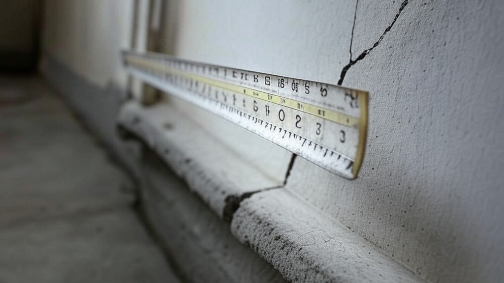
Crack Gauging and Evidence Integrity
Crack measurement should be consistent and repeatable. Use a transparent crack comparator to read maximum widths to ±0.1 mm, always holding it perpendicular to the surface. For ongoing reference, install non-invasive tell‑tale gauges only where permission is granted, and never drill unless explicitly authorized. Record initial readings and orientations, and photograph the setup. Build a crack register listing IDs, locations, widths, and dates. Finally, control the data: store files in a secure repository with version history, lock sharing to read-only for external parties, and capture sign-offs to close the loop. These practices safeguard the chain of custody and maintain trust in the evidence if a claim arises.
- Measure to ±0.1 mm with a comparator.
- Install tell‑tales only with permission.
- Photograph readings and installations.
- Maintain a dated crack register.
- Control access with versioned storage.
How to Use This Interactive Pre-Condition Survey Checklist
- Preparation: Gather tools (camera, 100 mm scale, crack comparator, tell‑tales, PPE), preload property IDs and plans, print consent forms, confirm scope exclusions, and test geotagging, timestamps, and photo upload from your device.
- Start Interactive Mode: Open the checklist, select the property ID, enable location/time capture, and attach photos directly to items; use comments to note access limits or owner requests.
- Document Systematically: Move exterior-to-interior where permitted; assign defect IDs, take scale-referenced photos, and enter crack readings in millimetres; keep all notes objective and non-diagnostic.
- Export and Share: Generate a commentable report and export as PDF/Excel; embed a QR code for verification; share read-only links with owners and the contractor.
- Sign-Off and Archive: Collect digital signatures from the reviewer and, where applicable, the owner; lock the report, archive in a versioned folder, and record distribution.

Call to Action
- Start Checklist Tick off tasks, leave comments on items or the whole form, and export your completed report to PDF or Excel—with a built-in QR code for authenticity.
- Download Excel - Adjacent Property Pre-Condition Survey
- Download PDF - Adjacent Property Pre-Condition Survey
- View Image - Adjacent Property Pre-Condition Survey
Cite & Embed
“Adjacent Property Pre-Condition Survey by Quollnet”
with a link to
this source page.
FAQ
Question: Do I need a structural engineer for a pre-condition survey?
Question: What photo quality and formats are recommended?
Question: How should I handle properties where access is refused?
Question: Where and when should crack gauges be installed?
Question: What if lighting or weather conditions are poor?
Related Articles
Broader reading and guidance connected to this checklist topic.
Is The Crack You See On Your Wall Serious Or Minor Cosmetic Issue?


Master Construction Project Cashflow With Cashflowpot

Is It Important To Customize Your Qr Code And How To Do It?
Related Checklists
Keep the workflow moving with nearby templates chosen from similar checklist content.